
Preston-under-scar is a regular stopping point on any Wensleydale road trip just to see how Dorlands Farm is looking after spending a lot of school holidays there. Parking at the usual parking spot for a hike up to the moors.
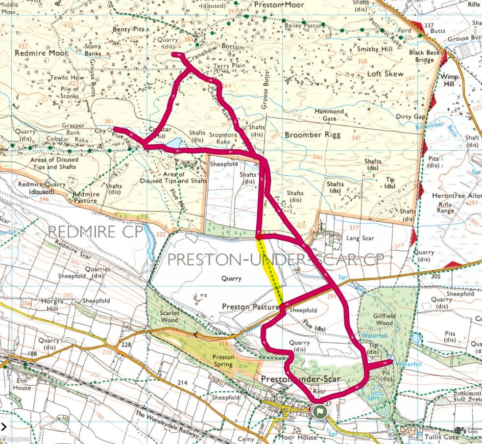
On the map image I have highlighted where one path on the OS App is no longer there due to the expansion of the quarry. The route is now just a fence with do not enter signs and a diversionary path around the quarry.
The route takes you up through fields onto the moors, following a gravel track past a pond and to some old mining building ruins. Then a quick trip further into the moors to a cairn and back to Preston-under-scar.


Leaving Tiggy at the side of the road in a quiet part of Preston-under-scar we set off northeast along the road signposted “Richmond 10”. We’re only heading along the road for a short distance, heading uphill and taking a gravel track to the left just after the last stone building which is Rock Cottage.

Follow the track for a short distance, turning off right and onto an uphill grass path through this field.

The path fits in-between some woods on the right and a field boundary fence on the left. A steady uphill climb to the scar and the moors beyond.


After passing through the woods you get this view of the scar. Don’t worry we’re not climbing up the cliff.

Follow the gravel track along the bottom of the scar where a path between these wire fences takes you up to the top.

Then head around a field and cross the road. It is here where the path stops due to the expansion of the quarry. This path ahead used to be the route but now it’s a steep drop into the quarry so a diversion to the right has been put in place. Follow the blue arrow sign.

And along this grass path turning 90 degrees to the left around the field.

Halfway along the diversion, looking west across the field to the expanded quarry beyond.

Keep following the new path around the field and closer to the quarry for more warning signs.

And a good view of the quarry workings.

Here, we’re back on track, taking the footpath north through a small wooded area and then over this stile onto the moors.

Continue along the footpath north alongside the fence line and past some grouse butts. #9.

Then hop over a stile and we’re onto the moors proper, following a gravel track. This junction below is where we’ll be heading back along the track to the right. For now we’re heading west, taking the lefthand track.

The track heads in a straight line west, passing this pond/lake. With the ruins of a chimney we’re heading to on the horizon.


A close up (sorry its bad) of some geese with their goslings.

The view across to Penhill, covered in the Up and Down Penhill Tour.

Back to the trek, keep following the gravel track west, heading towards the chimney.

As you approach these ruins take the path off to the right, towards the chimney.

The path follows alongside the ruins of a flue, towards the chimney.


The chimney itself.


After taking in the views, ruins and chimney it’s time to head back down the path back to the junction with the gravel track. This time taking the track heading uphill, northeast, to the field boundary at Cobscar Mill.

Through the gate and long the track you get to this Cairn.

Almost at the point where we turn back, I headed a little further along the track and up a grassy footpath for more views of the moors.


It’s then a case of retracing your steps, back along the gravel track to the cairn. Here, take the lefthand track, southeast back to the main track that headed east/west. Here, looking west one last time to the chimney in the distance.

The track then takes you back to this junction where we joined the track via the stile on the grassy path to the right. This time we’re keeping on the gravel track, over the cattle grid and following the road south.

Following the same route as the Up and Down Penhill Tour, passing between fields of sheep, towards the road.


Crossing the road here and heading straight ahead, following the sign to Preston.


After crossing the road junction, continuing south along the road with Gillfield Wood on the left. Time to quickly head along a track on the left to check out another pond/lake.

Then back to the road which bends to the right. It was a warm day, the sheep had the right idea.

Finally back to Preston-Under-Scar and Tiggy.
